The Malacca Cork: How Great Nicobar Island Transforms China's Deadliest Maritime Chokepoint
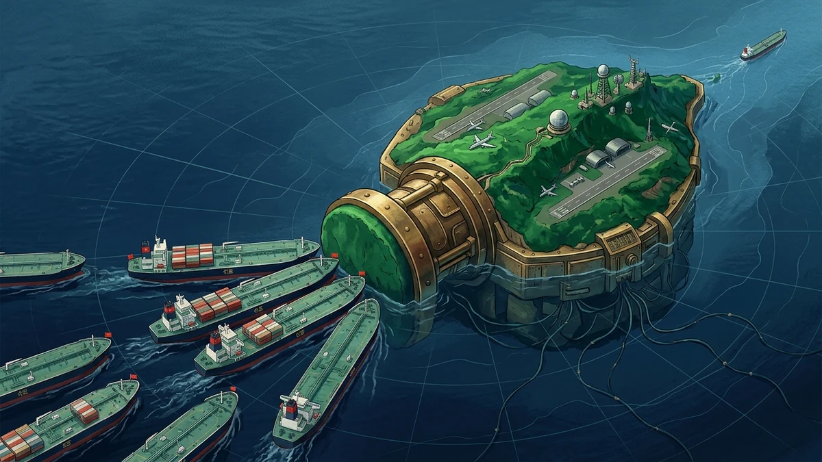
The Malacca Cork refers to India's strategic transformation of Great Nicobar Island—located at the western mouth of the Malacca Strait—into a fortified tri-service military fortress and international transshipment terminal. Sitting directly astride the Six Degree Channel (Great Channel), Great Nicobar provides New Delhi and Quad allies with geographic interior lines to physically monitor, track, and interdict up to 80% of China's seaborne crude oil imports during a Taiwan Strait or Himalayan escalation crisis.
Executive Assessment & Epistemic Frame
Executive Assessment: The operational buildout of India's $9.1 billion tri-service military and commercial transshipment hub on Great Nicobar Island fundamentally alters the maritime balance of power across the Indo-Pacific. Sitting at the mouth of the Six Degree Channel, Great Nicobar functions as an unsinkable aircraft carrier and naval cork that physically commands the western entrance of the Malacca Strait. In any major conflict over Taiwan or the Himalayan frontier, this node grants New Delhi and its Quad partners decisive horizontal escalation dominance over China's primary maritime energy corridor.
Analytical Confidence: HIGH | Commercial satellite imagery, official infrastructure procurement filings, and Indian Ministry of Defence deployments confirm active expansion of dual-use deep-water berths, extended runway corridors, and acoustic submarine monitoring arrays.
Key Uncertainty: The political willingness of Indian decision-makers to enforce full commercial maritime quarantines or visit-board-search-and-seizure (VBSS) operations during sub-threshold grey-zone crises.
Over 80% of China's seaborne crude oil imports transit the Malacca Strait, passing through the 90-mile-wide Six Degree Channel immediately south of Great Nicobar Island.
China's overland pipeline projects (CPEC, Myanmar) cannot offset a maritime blockade, leaving the People's Liberation Army Navy (PLAN) operating at a structural geographic disadvantage in the Indian Ocean.
By fortifying Great Nicobar, India converts a vulnerable colonial outpost into an offensive chokepoint lever, enabling pre-emptive deterrence without deploying surface fleets into the disputed South China Sea.
1. The Hydrography of Vulnerability: The Six Degree Channel as a Strategic Funnel
In classical maritime geography, sea control is determined by hydrographic chokepoints. While media attention frequently centers on the Taiwan Strait drone swarm battlefield and the South China Sea, the true Achilles' heel of Chinese grand strategy lies thousands of nautical miles to the southwest: The Six Degree Channel (Great Channel).
The Six Degree Channel is a narrow, deep-water maritime highway measuring approximately 90 nautical miles between Indira Point (the southernmost tip of Great Nicobar Island) and the northern coast of Sumatra (Aceh, Indonesia). Every Very Large Crude Carrier (VLCC) and Ultra Large Crude Carrier (ULCC) traveling from the Persian Gulf and East Africa toward East Asia must compress into this single navigational channel before entering the shallow, traffic-dense waters of the Straits of Malacca.
Because deep-draft commercial tankers cannot navigate alternative shallow routes (such as the Sunda or Lombok Straits) without incurring severe financial and temporal penalties, Great Nicobar commands an absolute geographic monopoly over East Asia's industrial energy supply lines.
2. The "Malacca Dilemma": Quantifying Beijing's Hydrocarbon Trap
Former Chinese President Hu Jintao famously coined the term "The Malacca Dilemma" in 2003, acknowledging that hostile naval powers could sever China's economic lifeline by blockading the strait. Over two decades later, despite hundreds of billions invested in the Belt and Road Initiative (BRI), Beijing's vulnerability has only intensified:
| Strategic Metric | China / PLA Exposure | India / Quad Leverage | Strategic Consequence |
|---|---|---|---|
| Crude Oil Transit Volume | ~80% of total oil imports | Zero transit exposure (domestic refining on west coast) | China's strategic petroleum reserve (SPR) provides ~90 days of emergency runway under total interdiction. |
| Naval Power Projection | Extremely extended supply lines (3,000+ NM from Hainan bases) | Short interior lines (ANC Headquarters at Port Blair & Campbell Bay) | PLA Navy surface combatants operate without land-based air cover or organic logistics in the Indian Ocean. |
| Commercial Reinsurance | Vulnerable to sovereign insurance withdrawal & Lloyd's war-risk premiums | Sovereign maritime enforcement & state reinsurance guarantees | Commercial tankers will refuse to enter the Six Degree Channel upon declaration of a war-risk zone. |
| Subsurface Surveillance | PLA Navy nuclear submarines (Type 093/094) restricted by thermal layers | P-8I ASW aircraft & underwater 'Fish Hook' hydrophone arrays | Chinese submarines are forced to surface or are acoustically tracked upon entering the Malacca bottleneck. |
3. The $9.1B Tri-Service Transformation of Great Nicobar
To convert this geographic endowment into operational combat power, New Delhi launched the Great Nicobar Holistic Development Project, an integrated infrastructure mega-complex encompassing four critical dual-use pillars:
A. The Galathea Bay International Container Transshipment Port (ICTP)
Constructed in the deep, natural harbor of Galathea Bay with a 20-meter draft, this transshipment port allows India to capture international cargo transshipment currently monopolized by Singapore and Colombo. Beyond its commercial utility, the facility is engineered with reinforced berthing infrastructure capable of accommodating Indian Navy aircraft carriers, guided-missile destroyers, and allied Quad auxiliary replenishment vessels.
B. The Campbell Bay (INS Baaz) Strategic Airstrip Expansion
Naval Air Station INS Baaz at Campbell Bay is undergoing runway expansion from 3,500 feet to over 10,000 feet. This enables forward staging and continuous combat operations for:
- Boeing P-8I Neptune Maritime Patrol Aircraft: Providing 24/7 airborne anti-submarine warfare (ASW) and radar coverage over the entire Malacca entrance.
- Su-30MKI & Rafale-M Strike Fighters: Equipped with air-launched BrahMos supersonic cruise missiles, capable of striking surface targets across the western Malacca approaches within minutes of takeoff.
- MQ-9B SeaGuardian High-Altitude Drones: Delivering long-endurance signals intelligence and maritime domain awareness across the Bay of Bengal and Andaman Sea.
C. The Subsea Acoustic Array ("The Metal Chain")
In coordination with Quad partners (specifically Japan and the United States), India has integrated seabed acoustic hydrophone arrays—commonly referred to in defense intelligence as the "Fish Hook" Sound Surveillance System (SOSUS). Strung across the seabed of the Six Degree Channel, these sensors detect the acoustic signatures of PLA Navy submarines attempting to enter the Indian Ocean, stripping Beijing of underwater stealth.
4. The Strategic Asymmetry: String of Pearls vs. Metal Chain
For over a decade, Western and Asian security analysts raised alarms over China's "String of Pearls" strategy—the development of commercial ports with dual-use military potential in Sri Lanka (Hambantota), Pakistan (Gwadar), Myanmar (Kyaukpyu), and Djibouti. Similar fears surrounded Beijing's megaport investments across South America, as detailed in our analysis of Chancay Megaport in Peru.
However, from a naval operational perspective, commercial ports in foreign countries are vulnerable isolated enclaves during wartime. China cannot defend Hambantota or Gwadar against superior carrier strike groups and land-based air power without sovereign basing agreements and defensive depth.
In contrast, the Andaman and Nicobar archipelago represents 572 sovereign Indian islands functioning as an unsinkable aircraft carrier. India possesses undisputed territorial sovereignty, hardened military infrastructure, and seamless logistical interior lines, turning the archipelago into an impenetrable "Metal Chain" that locks China out of the Indian Ocean.
5. The Escalation Dilemma: Horizontal Deterrence in a Taiwan Crisis
The primary strategic value of Great Nicobar is not to fight a localized war in the Bay of Bengal; rather, it provides Horizontal Escalation Dominance to deter or terminate a Chinese invasion of Taiwan:
```text THE HORIZONTAL ESCALATION MECHANISM ┌─────────────────────────┐ ┌─────────────────────────┐ ┌─────────────────────────┐ │ 1. Taiwan Strait Crisis │ ──> │ 2. Indian Ocean Non- │ ──> │ 3. Chinese Energy Panic │ │ (PLA Amphibious Assault)│ │ Kinetic Interdiction │ │ (90-Day Industrial Grid │ │ │ │ (Great Nicobar Blockade)│ │ Breakdown in Beijing) │ └─────────────────────────┘ └─────────────────────────┘ └─────────────────────────┘ ```If the PLA initiates an amphibious assault or naval quarantine against Taiwan, the United States and its allies may not need to rely solely on high-attrition kinetic clashes inside the First Island Chain. Instead, India and Quad partner navies can declare a Maritime Exclusion and Inspection Zone at the Six Degree Channel.
As explored in our foundational assessment of commercial lawfare as deterrence, international maritime insurers (Lloyd's of London) would immediately cancel war-risk coverage for Chinese-bound tankers entering the area. Commercial shipping would grind to an immediate halt without New Delhi firing a single missile, confronting the Chinese Communist Party with catastrophic domestic energy starvation within 90 days.
6. Beijing's Failed Bypass Routes: The Geography of Inevitability
Beijing has spent vast sums attempting to construct overland bypass routes to circumvent the Malacca chokepoint, but physical geography and engineering realities render these alternatives insufficient:
- The China-Pakistan Economic Corridor (CPEC - Gwadar): Pumping crude oil across the 15,000-foot Karakoram mountain range to Xinjiang requires enormous pumping energy, pipeline infrastructure vulnerable to insurgent sabotage, and delivers less than 5% of China's daily import demand.
- The Myanmar Pipelines (Kyaukpyu to Kunming): While operational, the dual oil and gas pipelines through Myanmar suffer from chronic throughput limitations (approx. 400,000 barrels/day vs. China's 11+ million barrels/day import demand) and pass through active civil war zones controlled by ethnic armed organizations (EAOs).
- The Northern Sea Route (NSR): As analyzed in our Arctic transit studies, the Arctic route remains seasonal, requires expensive icebreaker escorts, and cannot support high-volume VLCC supertanker fleets.
7. What to Watch: Critical Operational Indicators (2026–2030)
To monitor the operational maturation of the Malacca Cork, defense and intelligence analysts should track three primary indicators:
- Aviation Runway Completion at INS Baaz: Satellite verification of the 10,000-foot runway commissioning and permanent deployment of P-8I Neptune squadrons to Campbell Bay.
- Quad Logistics Access Agreements: Formal operationalization of the US-India LEMOA, Indo-French, and Indo-Japanese reciprocal logistics agreements allowing allied maritime patrol aircraft to refuel and rearm at Great Nicobar.
- Commercial Transshipment Dredging: Completion of deep-water dredging in Galathea Bay to 20-meter depths, establishing permanent berthing capacity for both commercial mega-containerships and capital naval vessels.
⚡ The ICS Strategic Briefing — Intelligence Dispatch
Track Indo-Pacific maritime chokepoints and great-power naval escalation. Receive weekly executive intelligence assessments covering maritime chokepoints, naval force posture, and sovereign infrastructure telemetry delivered directly to your inbox.
Expert Analysis — Pratyush Deo Tiwary
"Senior Analyst, Conflict Studies & Geopolitics: Strategic intelligence assessments in the Regional Conflict Evaluations arena indicate shifting operational dynamics. The technical telemetry and incident vectors analyzed here reveal calculated adjustments by state and non-state actors to exploit structural vulnerabilities before defensive countermeasures can be deployed. Continuous technical and geospatial verification remains paramount."
Related Domain Analysis: Explore our coverage of Geopolitics & Strategy.
Topical Bibliography & References
- Center for Strategic and International Studies (CSIS) (2025). "The Strategic Value of the Andaman and Nicobar Islands in Indo-Pacific Maritime Security" CSIS Asia Maritime Transparency Initiative (AMTI). [Source Link ↗]
- International Institute for Strategic Studies (IISS) (2025). "Energy Security and Naval Chokepoints: Assessing China's Indian Ocean Vulnerability" Survival: Global Politics and Strategy. [Source Link ↗]
- Royal United Services Institute (RUSI) (2026). "The Andaman Bastion: India's Tri-Service Command and Maritime Domain Awareness in the Bay of Bengal" RUSI International Security Studies. [Source Link ↗]
Key Takeaways
- Great Nicobar Island is positioned less than 90 nautical miles from Indonesia's Banda Aceh, dominating the primary commercial passage connecting the Indian Ocean to the South China Sea.
- China's economy remains acutely vulnerable to the 'Malacca Dilemma'—over 80% of its imported hydrocarbon energy and 60% of its total global trade traverses this single maritime funnel.
- The $9.1B Great Nicobar Infrastructure Project combines a dual-use International Container Transshipment Port (ICTP) with an expanded military air base capable of operating P-8I Neptune maritime patrol aircraft and frontline fighter squadrons.
- In a high-intensity crisis over the Taiwan Strait, the Andaman and Nicobar Command (ANC) provides India with non-nuclear horizontal escalation leverage—the credible capability to interdict Chinese-bound energy cargoes without firing in the primary theater.
- Beijing's bypass initiatives (CPEC Gwadar pipelines, Myanmar Kyaukpyu pipelines, Northern Sea Route) lack the throughput capacity to replace the volume of the Malacca maritime trade corridor.
Need a Deeper Operational or Threat Assessment?
International Conflict Studies provides custom open-source intelligence dossiers, geopolitical risk modeling, and critical infrastructure threat diagnostics for enterprise and sovereign decision-makers.
Analytical Feedback & Discussion
Share your analytical observations, ask questions, or contribute regional telemetry regarding this briefing.