The Eastern Flank: Why Taiwan's Pacific Approaches Define the Next Phase of Island Blockade
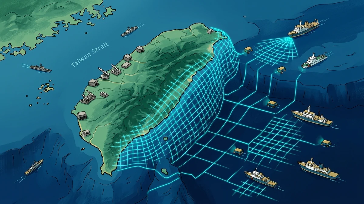
While international defense observers focus almost exclusively on an amphibious assault across the shallow Taiwan Strait, the People's Liberation Army (PLA) is quietly completing the operational architecture for a 360-degree island quarantine by targeting Taiwan's Pacific eastern flank. Chinese dual-use oceanic research vessels, subsea acoustic mapping crawlers, and continuous coast guard patrols in the deep Philippine Sea trenches are systematically mapping submarine ingress corridors and normalizing presence around Taiwan's eastern deep-water ports (Hualien and Suao).
Executive Assessment & Epistemic Frame
Executive Assessment: The completion of extensive Chinese seabed surveys and persistent coast guard patrols east of Taiwan marks a critical transition in cross-strait military geometry. Beijing is no longer planning for a localized cross-strait crossing; it is constructing a comprehensive 360-degree isolation architecture. By hydrographically mapping the deep submarine trenches of the Philippine Sea and regularly deploying carrier strike groups into Taiwan's eastern maritime approaches, the People's Liberation Army (PLA) aims to turn Taiwan's historic eastern sanctuary into a tactical trap, pre-empting US and Japanese resupply before kinetic conflict begins.
Analytical Confidence: HIGH | Commercial satellite imagery, Taiwan Ministry of National Defense tracking releases, and AIS research vessel telemetry confirm continuous PLA multi-domain presence east of the 122°E meridian.
Key Uncertainty: The rate at which the Japan Self-Defense Forces (JSDF) will deploy surface-to-ship missile (SSM) batteries and underwater acoustic listening nets across the Nansei/Ryukyu island chain to close China's Pacific transit corridors.
Chinese dual-use oceanic research vessels conducted systematic bathymetric seabed mapping east of Taiwan from August 10 to 31, while PLA combat aircraft and naval task forces established regularized multi-day operational tracks in the Philippine Sea.
This activity is not scientific exploration; it is military preparatory engineering designed to map underwater acoustic propagation channels and establish operational familiarity for anti-access/area-denial (A2/AD) submarine barriers.
If Taiwan's eastern ports (Hualien and Suao) are cut off from the Pacific, Taiwan's energy reserves (less than 11 days of natural gas) will force capitulation without requiring a contested beach landing.
1. Beyond the Strait: Why Geography Favors Encirclement
For decades, Taiwan's defense doctrine rested on a fundamental geographic assumption: the Central Mountain Range (reaching over 12,000 feet) shielded the island's eastern coastline from Chinese land-based artillery, short-range ballistic missiles, and direct amphibious assault. Hardened underground airbases at Jiashan (Hualien) and Chihhang (Taitung) were built inside granite mountains to protect Taiwan's fighter jets, allowing them to sortie out into the Pacific to conduct counter-attacks.
However, in our foundational analysis of The 30-Second Strait & Hellscape Strategy, we noted that China's modern naval modernization—specifically its commissioning of aircraft carriers (Fujian, Shandong) and Type 055 guided-missile cruisers—has eliminated this sanctuary. By operating in the deep waters of the Philippine Sea, PLA surface and subsurface battle groups can launch land-attack cruise missiles (LACM) directly into the unhardened eastern entrances of these mountain complexes.
2. The Hydrographic Dimension: Why Subsea Mapping Matters
The western Taiwan Strait is shallow (averaging 60 meters in depth), noisy, and heavily trafficked—making submarine operations exceptionally difficult. In stark contrast, the waters immediately east of Taiwan plunge rapidly into oceanic trenches exceeding 5,000 to 7,000 meters in depth (the Ryukyu Trench and Gagua Ridge).
| Operational Domain | Western Taiwan Strait | Eastern Pacific Flank | Strategic Significance |
|---|---|---|---|
| Water Depth & Topography | Shallow continental shelf (50–100m). | Deep abyssal plain & trenches (2,000–7,000m). | Deep water enables nuclear submarine thermal-layer evasion and silent cruising. |
| Primary Threat Vector | Amphibious barges, landing craft, FPV drone swarms. | Carrier strike groups, SSNs, long-range blockade cordons. | Shifts focus from kinetic beach defense to long-range anti-submarine warfare (ASW). |
| Allied Resupply Lines | Zero allied commercial traffic during wartime. | Primary corridor for US Pacific Fleet / Guam logistics. | Controlling the east cuts off allied munition replenishment and LNG tankers. |
| Legal / Sovereignty Status | Contested median line; heavy coast guard friction. | International waters & high seas EEZ overlaps. | Enables grey-zone normalization under freedom of navigation pretexts. |
By mapping the internal salinity layers, temperature gradients (thermoclines), and subsea canyons east of Taiwan, Chinese research vessels (such as the Haiyang Dizhi series) construct high-resolution acoustic models. In wartime, this data allows PLA Navy submarines to lie in wait along deep underwater ridges, ambushing approaching US carrier strike groups from Guam or Yokosuka before they enter weapon-release range.
3. The Blockade Mechanism: How the 360-Degree Quarantine Operates
An eastern encirclement transforms the nature of a Taiwan conflict from a bloody D-Day assault into a high-pressure customs and maritime quarantine, as analyzed in our study of commercial lawfare as deterrence:
- Declaration of Live-Fire Maritime Closure Areas: The PLA declares overlapping 'military exercise zones' completely ringing Taiwan, effectively severing international civil aviation and shipping corridors.
- CCG Boarding and Inspection Mandates: China Coast Guard (CCG) mega-cutters station themselves off Hualien and Kaohsiung, demanding the right to inspect incoming commercial cargo vessels for 'contraband munitions.'
- Commercial Reinsurance Paralysis: International underwriters refuse coverage for any container ship or LNG tanker attempting to dock at Taiwan ports, cutting off Taiwan's energy supplies without China firing a single missile.
4. Taiwan's Asymmetric Countermeasures: The T$1 Trillion Pivot
Recognizing the vulnerability of its eastern flank, Taiwan's President announced a record defense budget surpassing T$1 trillion ($31.5B USD). Crucially, the budget reallocates capital away from traditional expensive surface ships toward distributed asymmetric systems:
- Shore-Based Anti-Ship Missile Systems (HF-2, HF-3, Harpoon): Mobile truck-mounted missile launchers concealed along eastern mountain highways, capable of firing over coastal ridges at PLA warships 150+ miles out in the Pacific.
- Underwater Acoustic Arrays & Smart Sea Mines: Partnering with US and Japanese defense contractors to deploy automated seabed sensor nets across the Bashi Channel and Miyako Strait.
- Autonomous Drone Interceptor Networks: Procuring tens of thousands of maritime surveillance and strike drones to saturate approaching Chinese naval task forces with autonomous swarming attacks.
⚡ The ICS Strategic Briefing — Intelligence Dispatch
Track Taiwan Strait deterrence and Pacific naval escalation. Receive weekly executive intelligence assessments covering PLA naval posture, subsea bathymetric mapping, and Indo-Pacific chokepoint telemetry delivered directly to your inbox.
Expert Analysis — Pratyush Deo Tiwary
"Senior Analyst, Conflict Studies & Geopolitics: Strategic intelligence assessments in the Regional Conflict Evaluations arena indicate shifting operational dynamics. The technical telemetry and incident vectors analyzed here reveal calculated adjustments by state and non-state actors to exploit structural vulnerabilities before defensive countermeasures can be deployed. Continuous technical and geospatial verification remains paramount."
Related Domain Analysis: Explore our coverage of Geopolitics & Strategy.
Topical Bibliography & References
- Center for Strategic and International Studies (CSIS) (2026). "Encircle and Isolate: The Evolution of PLA Navy Operations East of Taiwan" CSIS China Power Project. [Source Link ↗]
- International Institute for Strategic Studies (IISS) (2026). "Undersea Bathymetry and Submarine Ingress: Chinese Research Vessels in the Philippine Sea" Strategic Comments. [Source Link ↗]
- Royal United Services Institute (RUSI) (2026). "Defending the Pacific Gateway: Taiwan's Eastern Bastions and Asymmetric Deterrence" RUSI Indo-Pacific Defence Forum. [Source Link ↗]
Key Takeaways
- A decisive Taiwan blockade does not require an amphibious landing; it requires severing the eastern deep-water maritime corridors through which Taiwan receives 98% of its energy imports and allied military resupply.
- China's multi-week seabed surveys east of Taiwan gather bathymetric and thermocline data essential for PLA Navy nuclear attack submarines (Type 093B/095) to operate stealthily in the Philippine Sea.
- Taiwan's eastern mountainous spine—historically viewed as an unassailable strategic sanctuary (Jiashan and Chihhang hardened underground air bases)—is now within range of Chinese carrier strike groups (Liaoning, Shandong, Fujian) and Pacific-deployed surface action groups.
- Taipei's response—surpassing T$1 trillion in defense spending with heavy investments in indigenous asymmetric drone swarms and anti-ship cruise missiles—reflects a transition toward distributed, multi-directional defense.
- Defeating an eastern flank encirclement requires coordinated US-Japan-Taiwan maritime domain awareness, rapid underwater sensor integration, and hardened Pacific naval logistics.
Need a Deeper Operational or Threat Assessment?
International Conflict Studies provides custom open-source intelligence dossiers, geopolitical risk modeling, and critical infrastructure threat diagnostics for enterprise and sovereign decision-makers.
Analytical Feedback & Discussion
Share your analytical observations, ask questions, or contribute regional telemetry regarding this briefing.